The Hudson River School
at the New-York Historical Society: Nature and the American Vision
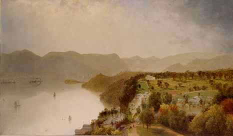
(above: John Frederick Kensett, View from Cozzens' Hotel
Near West Point, 1863, oil on canvas. The Robert L. Stuart Collection,
Stuart 189)
Exhibition Drawing Section Labels:
- First Gallery in Luman Reed Suite-Roberta J.M. Olson
-
- William Guy Wall and The Hudson River Portfolio
-
- In the summer of 1820 the Irish-born and trained landscape artist William
Guy Wall (1792-after 1864) went on an extended sketching tour of the Hudson
River Valley and its environs. A selection of Wall's watercolors recording
sights on his tour was engraved by the master printmaker John Hill (1770-1850)
in The Hudson River Portfolio, published in New York City
by Henry J. Megarey between 1821 and 1825. Long considered a cornerstone
in the development of American printmaking and landscape painting, its
twenty topographical views cover roughly 212 miles of the 315-mile course
of the Hudson River. This undertaking paved the way for a wider public
appreciation of landscape in the United States. The first series of prints
to make Americans aware of the beauty and sublimity of their own scenery,
the seminal Portfolio helped to stimulate national pride and cultural
identity and was so popular that it was reprinted in 1828 by G. & C.
& H. Carvill. It is no wonder that Wall is often seen as a forerunner
of the first group of American landscape painters to focus on American
subjects known as the Hudson River School.
-
- The Hudson River Portfolio follows the format of the well-established
English picturesque touring itineraries featuring both images and text.
All eight known extant watercolors preparatory for The Portfolio's
aquatints are in the Society's collection. They are exhibited in this gallery,
together with alternative views that were not reproduced as plates, nature
studies by Wall, and a selection of independent impressions of the plates
as well as a bound copy of the entire Portfolio.
-
-
-
- [First case on North Wall Next to Text Panel in Luman Reed Gallery
1]
-
- William Guy Wall (1792-after 1864), engraved by John Hill (1770-1850)
- The Hudson River Port Folio, 1821-25
- Open to Plate 15, View from Fishkill Looking to West Point
- Hand-colored aquatint
- (New York: Published by H.J. Megarey and G. & C. & H. Carvill,
1821-25, 1828)
- Gift of Daniel Parish, Jr., 1899
-
- Like most eighteenth- and nineteenth-century books of engravings, The
Hudson River Portfolio was issued serially in small groups of plates.
According to the prospectus printed on the inside cover of the first number,
the complete Portfolio was to be produced in six installments, each
of which was to contain four aquatints and text written by John Agg. Perhaps
because of the great expense of the project, only five numbers containing
twenty aquatints were actually issued though not in consecutive order.
The first four plates were begun by John Rubens Smith, whose work was reworked
by John Hill, the engraver of the remaining sixteen aquatints. Between
one and two hundred copies of each original plate seem to have been produced,
but the prints proved so popular that thousands of individual impressions
were sold in the late 1820s and 1830s. A second edition of the entire work
was published in 1828, and frequently plates of the three states (printings)
were bound together, as is the case with this volume.
-
-
- Second label
-
- Turning the pages of The Hudson RiverPortfolio gave the viewer
the sensation of traveling the Hudson even though most of Wall's views
were drawn from the land. The Portfolio suggests that Wall spent
much of his time on the upper reaches of the river. Despite the developing
vogue for wild scenery-and although the upper Hudson was only sparsely
settled-Wall's watercolors almost always emphasize ways in which settlers
manipulated the environment. Even when he drew potentially sublime waterfalls,
he almost always showed their power harnessed by human ingenuity.
-
- In his history of the arts in America published in 1834, William Dunlap
claimed Wall's preparatory watercolors were painted on the spot. However,
their size and finish suggest they may be studio works completed after
the artist's return to New York. No doubt they were based on field sketches,
such as the small one in graphite displayed on the south wall of the gallery,
a standard practice at the time.
-
-
-
- [Walls of Luman Reed Gallery 1]
-
- William Guy Wall (1792-after 1864)
- Preparatory Study for Plate 6 of "The Hudson River Portfolio":
- View of Glens Falls, New York, 1820
- Watercolor, selective glazing, touches of gouache, and scratching out
- on paper, laid on card, laid on canvas
- 1946.96
-
- Glens Falls is the first large town on the upper Hudson that the river
passes after emerging from the Adirondack foothills. North American Indians
called the sixty-foot fall "Chepontuo" ("a difficult place
to get around"). The name Glens Falls is derived from Colonel John
Glen of Schenectady, New York, who acquired land on which he built mills
in 1769. The hand-colored aquatint (plate 6 in The Portfolio), for
which this watercolor served as the model, is also exhibited in the gallery.
-
-
- William Guy Wall (1792-after 1864)
- Preparatory Study for Plate 7 of "The Hudson River Portfolio":
- View Near Sandy Hill, New York, 1820
- Watercolor gouache, selective glazing, and scratching out on paper,
- laid on card, laid on canvas
- Gift of The New-York Gallery of the Fine Arts, 1858.79
-
- The plate engraved by John Hill was published in 1822-23. Its accompanying
text notes: "To the eye accustomed to dwell on the calm and cultivated
beauty of a European landscape, if the scenery of the annexed engraving
appear defective in some of those features which lend grace and animation
to a picture, it affordsa cheerful and striking contrast to thegrandeur
of the Highlands. Here the Hudson forfeits its right to the name of the
North River, suddenly departing from its accustomed course, and conducting
its waters in a western direction. The fall of water, in this place, is
very diminutive, although sufficient to keep the mill in operation which
speculative industry has erected upon it. The section of roadis that leading
to Glen's Falls, Lake George, &c."
-
-
- William Guy Wall (1792-after 1864)
- Preparatory Study for Plate 8 of "The Hudson River Portfolio":
- View of Baker's Falls, New York, 1820
- Watercolor, selective glazing, gouache, graphite, and touches of scratching
- out on paper, laid on card, laid on canvas
- 1946.97
-
- Baker's Falls was named after Albert Baker who came to Washington County
north of Albany near Saratoga and Lake George in 1768. He built a dam and
saw mill at the falls that are believed to be the highest on the mighty
Hudson River. A town by that name was built near an Iroquois trail and
remained a vital travel route through the American Revolution. In 1810
the name Baker's Falls gave way to Sandy Hill, a name the village held
until it was changed to Hudson Falls in 1910. Wall's watercolor contains
a towering pine in the right foreground not present in the engraved view.
It is one of the most obvious changes, as most of Hill's aquatints follow
Wall's original watercolors very closely.
-
-
- William Guy Wall (1792-after 1864)
- Preparatory Study for Plate 10 of "The Hudson River Portfolio":
- View Near Fort Edward, New York, 1820
- Watercolor, scratching out, selective glazing, and touches of gouache
and black
- ink on paper, laid on card, laid on canvas
- James B. Wilbur Fund, 1941.1119
-
- During the French and Indian Wars, Fort Edward was a military post
of considerable importance on the upper waters of the Hudson River. By
1820, when Wall executed this view of the river and village, Fort Edward
had become a quiet river town that had passed its years of adventure and
importance. At this point the Hudson flows through a widening valley of
farms and small towns, continuing its descent through gentle rapids to
the head of tidewater at Troy, New York. The text of The Hudson River
Portfolio points out that the southern turnpike road, from which the
artist drew the vista, is in the foreground.
-
-
- William Guy Wall (1792-after 1864)
- Preparatory Study for Plate 15 of "The Hudson River Portfolio":
- View from Fishkill Looking to West Point, New York, 1820
- Watercolor, selective glazing, white gouache, graphite, and scratching
out
- on paper, laid on card
- 1946.95
-
- West Point and other Revolutionary War sites were popular destinations
with visitors from all parts of the United States and Europe. This is a
view from Fishkill Landing on the east shore of the Hudson toward the north
gate of the Hudson Highlands. Denning's Point is in the center of Wall's
composition, and beyond is Polopels Island. The bound copy of The Hudson
River Portfolio in the exhibition is open to this plate for comparison.
-
-
- William Guy Wall (1792-after 1864)
- Preparatory Study for Plate 17 of "The Hudson River Portfolio":
- View near Fishkill, New York, 1820
- Watercolor, graphite, selective glazing, and scratching out with touches
- of gouache on paper, laid on card
- Gift of John Austin Stevens, 1903.14
-
- The text accompanying the engraving, published in 1823-24, describes
the scene: "This view represents the Landing at Fishkillone of those
beautiful elbowsin the winding course of the Hudson River. The expanded
amphitheatre in which heroes have acted their parts, it is a hallowed spot
to the historian; and clothed in all the sublime grandeur of her own inaccessible
majesty, where nature attracts, yet mocks, the puny efforts of human art,
the painter and the poet will ever find their worthiest and most attractive
models. This landing is situated a little to the north of West Point. The
mountains in the vicinity of Fishkill, or Matteawan as it was called by
the Indians, are covered with wood."
-
-
- William Guy Wall (1792-after 1864)
- Preparatory Study for Plate 18 of "The Hudson River Portfolio":
- View Near Fort Montgomery, New York, 1820
- Watercolor, scratching out, and selective glazing with touches of gouache
- on paper, laid on card
- James B. Wilbur Fund, 1941.1124
-
- The text for the hand-colored aquatint by John Hill in The Hudson
River Portfolio reads: "The accompanying view looks down the Hudson,
and affords one of those happy groupings of mountain and water scenery,
whichare so abundant. The artist, however, has displayed a judicious discretion
in making choice of a subject which combines historical interest with picturesque
beauty. In the fall of the year 1777, the vicinity of Fort Montgomery was
the scene of military operations of no mean importance. This fort and Fort
Clinton were considered the main defences [sic] of the highlands."
- The placid waters punctuated by the central barge depicted by Wall
were to become an iconic image in American painting.
-
-
- William Guy Wall (1792-after 1864)
- Preparatory Study for Plate 19 of "The Hudson River Portfolio":
- View of the Palisades, New Jersey, 1820
- Watercolor, graphite, and scratching out with touches of gouache on
paper,
- laid on card
- Gift of John Austin Stevens, 1903.13
-
- The Palisades are a line of steep, vertical cliffs along the west side
of the lower Hudson River. They stretch north from Jersey City, approximately
forty miles to High Tor Mountain near Haverstraw, New York. Ranging in
height between 350 to 550 feet, the cliffs are among the most dramatic
geological features in the vicinity of New York City, forming a canyon
north of Fort Lee, New Jersey, and providing a dramatic vista of the City.
Wall has shown their stark splendor dwarfing both sailboats and steamboats
typical of the types that plied the Hudson's waters, a juxtaposition also
shown in Hill's aquatint displayed nearby in the gallery.
-
- Life on the river was transformed when Robert Fulton, in partnership
with Robert R. Livingston, inaugurated a new era of navigation in 1807,
piloting his "North River Steamboat," later known as the Clermont
on the Hudson. Fulton's commercially viable steam-powered boat revolutionized
transportation between New York and Albany. Its ability to operate on a
predictable schedule ushered in a new age of technological advancement
that influenced trade, transportation, and tourism on the Hudson River.
-
-
- [Unused studies for the The Hudson River Portfolio}
-
- William Guy Wall (1792-after 1864)
- View of the Hudson River at Hudson, New York, 1820
- Watercolor, scratching out, selective glazing, gouache, and graphite
- on paper, laid on card
- James B. Wilbur Fund, 1941.1120
-
- Hudson, New York, was established in 1783 by New Englanders from Nantucket
and named in honor of Henry Hudson, the English navigator who explored
the river for the Dutch in 1609. Despite its location 120 miles from the
ocean, Hudson carried on a flourishing whaling industry. Wall drew this
broad vista of the river from the summit of Mount Merino. The city appears
at the right, and in the river is the long mud flat through which a canal,
seen at the center, was cut for the passage of the Hudson-Athens ferry.
Although Wall intended this watercolor for The Hudson River Portfolio
it was not included in the published work. It may have been planned for
the sixth and final, never executed installment.
-
-
- William Guy Wall (1792-after 1864)
- View of the Hudson River at West Point, New York, 1820
- Watercolor, scratching out, white gouache, and selective glazing on
- paper, laid on card
- James B. Wilbur Fund, 1941.1121
-
- This watercolor was executed for The Hudson River Portfolio
but was not included as one of the plates depicting the area around
West Point. An alternate view, its vista looks south from the high ground
behind Constitution Island toward the two peaks of Anthony's Nose and Bear
Mountain. The river threads its way between high hills, called the Highlands,
which rise from both banks. The buildings of the United States Military
Academy appear on the level plain at the right, and on the summit of the
nearby hill are the ruins of Fort Putnam.
-
-
- William Guy Wall (1792-after 1864)
- View in the Hudson Highlands, New York, 1820
- Watercolor, scratching out, and selective glazing on paper,
- laid on card
- James B. Wilbur Fund, 1941.1123
-
- A view north from the west shore of the Hudson River, this unused watercolor
was one of three alternate views by Wall for The Hudson River Portfolio
in the Society's collection. Con Hook Point, a cape near West Point, is
represented in the center, and the Sugar Loaf Mountain is depicted at the
right.
-
-
- [Additional Drawings by Wall for Luman Reed Gallery 1]
-
- William Guy Wall (1792-after 1864)
- Landscape with Covered Bridge Across the Sacandaga River,
- Hadley, New York, ca. 1820-25
- Watercolor, selective glazing, scratching out, gouache, and graphite
on paper
- Watson Fund, 1962.78
-
- Wall may have intended this watercolor for The Hudson River Portfolio
although its larger dimensions also suggest it may have been created for
another purpose. The bridge was built by Obadiah Wilcox in 1813. In 1836
Thomas Cole may have been influenced by Wall's earlier image when he made
sketches of the bridge from almost the same spot (in his sketchbook in
the Detroit Art Institute). Wall rendered a different landscape of the
same locale for plate 2 of The Portfolio, engraved by John Hill
and published in 1821-22 as The Junction of the Sacandaga and the Hudson
Rivers, also exhibited in this gallery.
-
-
- William Guy Wall (1792-after 1864)
- View of Esopus Creek at Saugerties, New York, ca. 1830
- Watercolor, scratching out, black ink, selective glazing, and
- graphite on paper
- Gift of Samuel Verplanck Hoffman, 1923.126
-
- This watercolor preserves a vista not found in The Hudson River
Portfolio. Esopus Creek, in the Ulster County, New York, section of
the Catskill Mountain region, flows from its source high on Slide Mountain
twenty-six miles to Ashokan Reservoir.
-
-
- William Guy Wall (1792-after 1864)
- Study for an Engraving:
- View of Barclay's Iron Works, Saugerties, New York, ca. 1830
- Watercolor, graphite, scratching out, selective glazing, and
- white lead pigment on paper
- Gift of Samuel Verplanck Hoffman, 1923.127
-
- This small watercolor was engraved by Fenner Sears and Co., London,
and published by I.T. Hinton & Aimpkin & Marshall in 1831. An impression
is in the Society's print collection. The town of Saugerties dates back
to April 27, 1677, when New York's Governor Andros signed a land deal with
the Esopus Indian Kaelcop, Chief of the Amorgarickakan Family, paying the
family a blanket, a piece of cloth, a shirt, a loaf of bread, and some
coarse fiber. It is located between the majestic Catskill Mountains and
the scenic Hudson River, ninety miles north of New York City and forty
miles south of Albany.
-
-
- William Guy Wall (1792-after 1864)
- Landscape of the Hudson River; from the disassembled
- Cummings Album, ca. 1818-28
- Graphite on heavy paper
- Gift of Mr. Whitney Hartshorne, 1979.45
-
- This small, irregular sheet may record the entrance to the Hudson Highlands.
It preserves the type of sketch Wall executed on location outdoors in preparation
for his larger, more finished watercolors painted in the studio. These
watercolors in turn were used by John Hill to engrave the plates for The
Hudson River Portfolio. While it has no exact correspondence to
either a larger watercolor by Wall or a plate in The Portfolio,
the vista resembles several views, especially those near West Point and
Fort Montgomery, reproduced in the famed collection.
-
-
- William Guy Wall (1792-after 1864)
- Sketch of a Tree, ca. 1830
- Brown ink on paper with lines on verso, laid on paper
- Gift of Robert William Glenroie Vail, 1948.623
-
- Wall's tree sketches drawn in nature resemble in spirit contemporary
drawings by Thomas Cole and foreshadow the many later studies of trees
drawn by Asher B. Durand.
-
-
- William Guy Wall (1792-after 1864)
- Study of a Tree Trunk; from the disassembled
- Cummings Album, ca. 1818-28
- Graphite on paper
- Gift of Mr. Whitney Hartshorne, 1979.43
-
-
- [The Hudson River Portfolio plates in cases]
-
- John Hill (1770-1850) after William Guy Wall (1792-after 1864)
- Junction of the Sacandaga and Hudson Rivers,
- No. 2 of "The Hudson River Port Folio," 1821-22
- Hand-colored aquatint
- Gift of George A. Zabriskie, 1939
-
- The adjacent text reads: "The Hudson river receives the water
of the Sacandaga, at the village of Luzerneabout fourteen miles west of
Sandy-Hill, and about two hundred and twenty-four from New-York. There
are some considerable rapids at this place, which are dignified by the
name of the Little Falls. The shoresare broken and precipitous; and the
natural course of the current is impeded and distracted by the large fragments
of stone. The character of the scenery is a wild, ferocious, and solitary
sublimity; lofty and irregular acclivities, covered with the gloomy verdure
of interminable forests and glens. The forests of Luzerne are principally
of white pine. The time of day represented in the engraving is morning."
-
-
- John Hill (1770-1850) after William Guy Wall (1792-after 1864)
- Rapids Above Hadley's Falls,
- No. 4 of "The Hudson River Port Folio," 1822-23
- Hand-colored aquatint
- Gift of George A. Zabriskie, 1939
-
- The commentary notes that: "This view of the Rapids was taken
from a favourable point between the Falls and Jessup's Landing, where the
Hudson sweeps round an elbow of stupendous rocks, just before it takes
its leap over the precipice which gives the name to the great falls. The
bed of the river is here sunk between two magnificent walls of perpendicular
cliffs, which rise to the height of 70 to 80 feet. Towering and massive
rocks are, perhaps, the most striking images of solitude and sublimity.
The picture before us exhibits images of this character, in their fullest
perfection; and, in combination with another feature of the grand and impressive
orderconveys to the mind a most effective idea of romantic loneliness.
The excellence of Mr. Wall's water scenery has been before alluded to."
-
-
- John Hill (1770-1850) after William Guy Wall (1792-after 1864)
- Glenns Falls,
- No. 6 of "The Hudson River Port Folio," 1822
- Hand-colored aquatint
- Gift of George A. Zabriskie, 1939
-
- According to The Portfolio's text: "GLENN'S FALLSpresent
to the eye of the spectator immense masses of water, rushing down over
broad platforms of rock, in a hundred rival cataracts, and as many different
directions. Instead of one precipitous and unbroken leap, therefore, the
Hudson in this place, descends, by an almost regular series of capacious
steps, forming a variety of cascades of an imposing extent, and of incomparable
beauty. The height of the entire fall is estimated at near seventy feet.
The building in the centre of the bridge is a toll-house, where the curious
traveler may generally purchase some of the rarest specimens of fossil
petrifactions [sic]. In the summer of 1821, about two hundred square feet
of the solid rock, which overhung the beach, suddenly separated itself
from the main mass, and fell, with a thundering crash, into the waters
beneath."
-
-
- John Hill (1770-1850) after William Guy Wall (1792-after 1864)
- View Near Fort Miller,
- No. 10 of "The Hudson River Port Folio," 1821-22
- Hand-colored aquatint
- Gift of George A. Zabriskie, 1939
-
- In the first state (printing) this is plate 10 and in the subsequent
state plate 9. Its text begins: "VIEW NEAR FORT MILLER BRIDGE. / FORT
MILLER is a small village in the township of Argyle and Washington county;
thirty-seven miles north of Albany, and thirteen south of Sandy-Hill. The
great post-road from Albany crosses the bridge at this place. There are
some considerable rapids and falls near this place; the latter of which
were about eight feet in height when this view of the river was taken.
Over these falls it is by no means unusual for raftmen to precipitate their
rafts. General Putnamis said to have been the first who tried this daring
achievement. A party of Indians came suddenly upon him, as he was lying
near the rapids with a bateau and five men. The situation of this village
is pleasing; the country about it picturesque; and the soil favourable
to cultivation."
-
- John Hill (1770-1850) after William Guy Wall (1792-after 1864)
- West Point,
- No. 16 of "The Hudson River Port Folio," 1825
- Hand-colored aquatint
-
- "WEST-POINT is so well known, that any description of this place
seems, in these times of close and continual intercourse, to be almost
unnecessary. There is scarcely a traveler who has visited the Highlands,
who has not concentrated his attention, at least for a few minutes, on
the situation and character of this nursery of military talent, this school
of tactics, and prolific fountain of future glory and security. Standing
on a commanding elevation, in the center of a panoramathe mountain air
is propitious to bodily health; the unbroken calm which perpetually reigns,
induces the mind to apply to those resources, and every spot is rendered
sacred by association with times and circumstances which 'tried men's souls,'
and which now live only in memory, or rather, in history."
-
-
- John Hill (1770-1850) after William Guy Wall (1792-after 1864)
- Palisades,
- No. 19 of "The Hudson River Port Folio," 1823-24
- Hand-colored aquatint
-
- The adjacent description reads: "The Pallisadoes [sic] consist
of a line of rugged and perpendicular bluffs. To the eye of the traveller,
rising in savage grandeur, and stretching their tree-crowned summits far
as the vision can compass, these rocks are too prominent a feature in the
scenery of the Hudson to be overlooked. The height of these bluffs is various,
rising from 400 to 800 feet, exhibiting, in every interval of verdure,
steep and solid masses of stupendous stone, and presenting here and there
deep cavities, where the eagle builds his nest among the cliffs, secure
from the reach of human enmity. From the quarries at the foot of these
rocks, inexhaustible supplies of stone are transported to the city. The
bold and rocky middleground of this picture is peculiarly characteristic
of the scene, and the thinness and liquid transparency of the water along
the shore are inimitable."
-
-
- William Guy Wall (1792-after 1864)